Route no. 3 · start & finish Can Pastilla
Sa Ràpita
- Moderate
- 100 km
- 575 m
- ≈ 3½–4½ h
Map and elevation profile
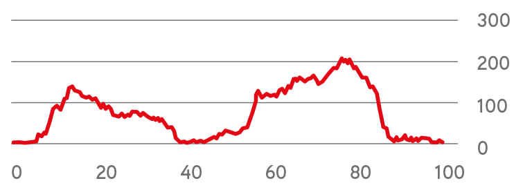
Move along the elevation profile to see where you are on the map.
Food & coffee stops
Tried-and-tested places where cyclists like to stop for coffee, food or water.
-
Restaurant 42 kmRestaurant Club Nàutic Sa Ràpita Sa Ràpita
Harbour terrace with views over the marina and the bay, recommended by more than 80 road cyclists on Komoot. Opens at 8 am, closed on Tuesdays.
Open in maps ↗ -
Café 52 kmPastisseries Pomar Campos
The Pomar family's historic cake shop, trading since 1902 on Carrer de Plaça by the main square, about 170 m off the route at km 52: ensaïmadas, plain or filled with cream or apricot, and coffee at tables inside and out. Open daily 7:00–20:00.
Open in maps ↗ -
Café 62 kmBar ca'n Guillem Porreres
Family-run bar with a terrace on the main square (Av. Bisbe Campins 1), right on the route, with bike racks by the tables. Open daily from 6 am.
Open in maps ↗
Charming Sa Ràpita Is Best Seen by Bike
Route summary:
This route leads across the flat south-eastern part of the island towards the small town of Sa Rapita. The terrain is easy and the whole route can be done in 3.5 to 5 hours depending on your average speed. Sa Rapita, Campos (for the pastry shop by the main square), Porreres or Algaida are the best places to stop. This trip is suitable for the first days of your stay or when getting familiar with riding in a large group of cyclists. Along the way, you get some spectacular views of the island’s coastline, beautiful beaches, and the historical town of Sa Rapita. We should also mention the small town of Campos with its rich history and ancient stone houses typical for the island. There is also a place called Porreres at the 62nd kilometre of the route, where you might visit a café or the Baroque Nostra Senyora de la Consolació church.
 Cycling route summary:
The initial 40 kilometers of the route, follow the southeast coast of the island. It has a slightly hilly profile. However, it does not hide any difficult ascent and will easily take you to the town Sa Rapita. You can recharge the energy there and enjoy beautiful beach views. The following inland passage through Campos and Porreres is still flat. It has the only exception of two smaller swingy hills. They are a great place to compete against your friends. You will then ride 20 kilometers to Algaida, followed by the last part of the route being completely flat or slightly descending.
 Tourist summary:
The start and end of this route are in Palma Aquarium. The first 22 km of the route are along the coast, through places like Son Veri Nou or Ses Palmeres. These locations are known mainly for its popular beaches. Just before the beach Cala Pi, the route turns away from the sea and returns back to it in Sa Rapita. Sa Rapita is the main destination of this route. The way back to the starting point goes through the inland.
This is an easy to medium-difficulty route, due to the distance and the climbed height meters. You might need 4-5 hours to complete it, depending on your ability.
Climbs click to show on the map
- Arenal – Badia Blava (Ma-6014) from s'Arenal, Ma-6014 (31 m) 5.5 km · Ø 2 % · top 141 m km 7–12
Tips from our guides
- At 100 km this may be your first century. Eat every 45 minutes and refuel in Sa Ràpita (km 40) and Porreres (km 61). The Club Nàutic is closed on Tuesdays.
- Great for group practice. Spanish rules let you ride two abreast, but go single file on blind stretches or when traffic backs up; drivers must leave 1.5 m when overtaking.
- Legs still fresh? From Porreres a short detour climbs 1.8 km at 6.2% to the Monti-Sion sanctuary (235 m), with views over the town and the plain.
- Start early. In summer the south-westerly embat sea breeze builds from mid-morning, so the run home from Algaida back to the sea can be into the wind.
- Carry two bottles – the Campos plain gets hot and shade is rare. Only drink water marked 'agua potable'; decorative fountains are often not drinkable.
Did you know?
- Es Trenc begins right next to Sa Ràpita: about 10 km of sand and dunes stretching to Colònia de Sant Jordi, all within a protected natural area. source
- Behind the beach lies the Salobrar de Campos, the island's second-largest wetland. Salt was already gathered here in antiquity, and flamingos visit too. source
- Porreres is Mallorca's apricot town: around 70% of the island's apricot trees grow here, celebrated every June at the Fira de l'Albercoc. source
Places along the route
-
140 km
Sa Rapita
Sa Rapita is a town whose main task in the 16th - 19th century, was to warn the population against fires and pirate attacks, coming from the south.
The Son Duri watchtower is still standing. It still looks like it is looking for ships with a pirate flag on the mast.
Today it is one of the places with the most beautiful beaches on the island. The historic center has a pleasant atmosphere and the option of shopping in local, traditional shops.
-
251 km
Campos
The city was officially founded by King Jaume II, in 1300, based on the Roman settlements. The main monument of the city is the Church of Sant Julia with paintings of Jesus Christ. The author is the painter Bartolomeo Estaban Murillo.
The famous local markets open every Thursday and Saturday. You can buy there some traditional specialties, like sobrasada and cheese.
-
361 km
Porreres
A small town with a seemingly sleepy atmosphere, but the appearance is deceptive. Its history dates back to the Bronze Age. Arab and Roman settlements bring in mind wells, used to be used by humans or animals. The current city name was given after its conqueror, William of Porreres. A sad historical event is a small revolution called "famous", during which the town hall burned down with 600 years of historical documentation. It coincides with the fall of Queen Isabella II in 1868.
The main street is Avinguda Bisbe Campins. It is a pedestrian area with many cafés, bars and the Baroque church of Nostra Senyora de la Consolació.
If you like modern art, you might be impressed by the Salvatore Dali exhibition in the town hall. And of course, there is a traditional marketplace as well.
-
476 km
Algaida
Algaida has a population of 4,500. The origin of the name can be found in Arabic. It means "base".
The first written records date back to 1232. The city's sights are the Mare de Déu de la Pau de Castellitx, pilgrimage chapel and several windmills. The city also has the oldest glass blowing factory in Mallorca. You can still see the local glassmakers producing art objects in the workshop of the Gordiola family.
-
594 km
S ´Aranjassa
A small village on the route between Palma de Mallorca and the airport. Although it is a small village, with only 1,000 inhabitants, you will find there traditional architecture buildings.
More routes
All routes →Rides of similar difficulty you might also like.